Nuova Pianta di Roma

Nolli, Giambattista Nolli, Leonardo Bufalini, and Joseph Rykwert. Nuova pianta di Roma data in luce da Giambattista Nolli, l’anno MDCCXLVII. London: Architecture Unit, Polytechnic of Central London, 1977.

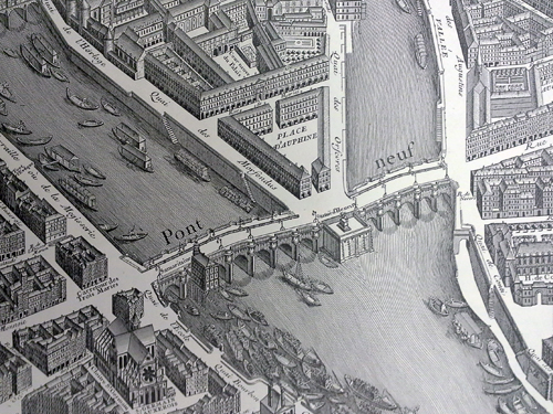
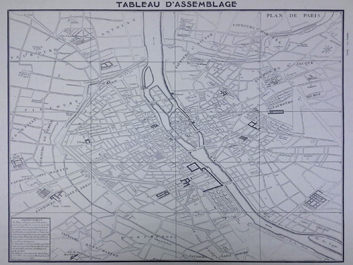
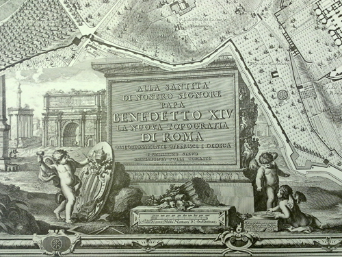
Along with the maps of Paris, several other map facsimiles were transferred from the Alexander Architectural Archive to the Architecture and Planning Library. One of these was Nuova pianta di Roma data in luce da Giambattista Nolli, l’anno MDCCXLVII, a 1977 reproduction of Giambattista Nolli’s (1701-1756) famous ichnographic map of Rome. Nolli began survey work on his map in 1736 and the map was published in 1748. Composed of twelve copper plate engravings that could be assembled into a nearly six by seven foot display, the “Nolli map” was revolutionary for both its accuracy (down to the asymmetry of the Spanish Steps!) and the way it distinguished between open civic and closed private spaces rather than simply denoting interiors and exteriors. This meant that not just the streets, but the cathedrals, Pantheon, and colonnades of St. Peter’s, were left white, while private buildings, walls, and columns were shaded in poché. The map, which is beautifully rendered in crisp black and white, is framed by Stephano Pozzi’s (1699-1768) elaborate vedute depicting St. Peter’s Square.

In addition to the Nolli map, this publication by Polytechnic College of London (now the University of Westminster) includes an introduction by the University of Pennsylvania’s Paul Philippe Cret Professor of Architecture Emeritus, Joseph Rykwert (1926- ), as well as Nolli’s reproduction of Leonardo Bufalini’s 1551 Pianta di Roma. An interactive version of the map, created by professors at the University of Oregon, can be seen here.

Library of Congress call number: Coming Soon!

Wrapping up the Blake Alexander Project

Blake Alexander (fourth from left) and other faculty members from the School of Architecture, along with students, at a small restaurant in Round Top (or nearby), Texas. ca. the early 1980’s

I’m in the last few days of my project processing the Blake Alexander Collection, and while I’m happy that it’s nearly in a stage to open it up for researchers, I’m sad to leave.  I graduated a few weeks ago and am now moving on from my Graduate Research Assistant position.

The collection will be ready for researchers soon, and I hope that you are as excited as I am about its usefulness.  There are so many materials in the collection which could be used for so many different types of research.  However, the ones that I find the most useful are:

  • Curriculum Development at the University
  • Historic Preservation in Texas
  • The Architectural History Profession in the US
  • University campus and buildings history
  • Images of Texas architecture

I had the opportunity to present my work at the Society of Southwest Archivists Annual Meeting in Austin last week, and I’ve included the poster which I presented below.

Processing of a Foundation Collection: Blake Alexander’s Materials at the Alexander Architectural Archive
Jarred Wilson and Donna Coates at the Society of Southwest Archivists Annual Meeting in Austin

I chose the image above for this blog post because I feel like it does a good job of capturing the spirit of the School of Architecture at the time.  Blake Alexander gave so much of his time, energy, and efforts to promoting the historic preservation and architectural history programs in the School of Architecture and beyond, and I think that this photo speaks to the camaraderie which he fostered.  However, we don’t have all of the people in the photograph identified.  Do you know who some of them are?  If so, please comment on this post and let us know.  And, check back soon for a completed finding aid for this collection.

Wagner’s Ice House, across the road from the Winedale Historical Center. Summer 1986.(Click on the image to enlarge it)
  1. Jim Kistler
  2. Kathy Edwards
  3. Bob Harding
  4. Ann Yaklovich
  5. Ralph Newlan
  6. Maggie Gibbons
  7. John Mayfield
  8. David Franks
  9. Rick Lewis
  10. Anthony DeGrazia
  11. David Thompson

Plan de Turgot

Bretez, Louis. Paris au XVIIIe siècle; Plan de Paris en 20 planches dessiné et gravé sous les ordres de Michel-Étienne Turgot, prévôt des marchands. Commencé en 1734, achevé de graver en 1739. Levé et dessiné par Louis Bretez. Paris: A. Taride, [1908?].

Bretez, Louis, André Rossel, and Michel-Etiene Turgot. Le Plan de Louis Bretez dit Plan de Turgot. Paris: Éditions les Yeux ouverts, [1966?].

Recently, the Architecture and Planning Library took possession of several books, that were originally housed in the Alexander Architectural Archive. These books, formerly owned by the late Blake Alexander, were transferred to the library’s special collections in order to allow greater access to students and researchers alike.

Two of the books, officially titled Paris au XVIIIe siècle; Plan de Paris en 20 planches dessiné et gravé sous les ordres de Michel-Étienne Turgot, prévôt des marchands and Le Plan de Louis Bretez dit Plan de Turgot, represent different twentieth century facsimiles of a the same publication, Le Plan de Turgot. Le Plan de Turgot, a detailed bird’s-eye view of Paris, is one of the most famous urban maps ever created. Commissioned by the prévôt des marchands de Paris, Michel-Étienne Turgot (1690-1751), in 1734, the map was realized by Louis Bretez over the course of five years. Bretez, a member of the Académie royale de peinture et de sculpture who specialized in architectural perspective, was given free reign to enter Paris’ mansions, houses and gardens in order to capture every building, window, tree, shadow and park in exhausting (and accurate!) detail. The completed map, consisting of twenty pages that could be assembled into a massive display of the first eleven modern-day arrondissements, was engraved by Claude Lucas and published in 1739. Lucas’ original plates are kept by the Chalcographie du Louvre where they could still (theoretically) be used today for printing.

Of the two reproductions, Paris au XVIIIe siècle, is the oldest. This book was published circa 1908 by Alphonse Taride, a Paris based publisher who specialized in maps, tourist guides, histories, and pocket plans of France. The other facsimile, Le Plan de Louis Bretez dit Plan de Turgot, is much newer having been published circa 1966 by Éditions les Yeux ouverts.

Library of Congress call numbers: -F- 912.4436 B755P and -F- 912.4436 B755P 1966.